Satellite-based Preliminary Design and Route Alignment in Remote, Inaccessible Areas

Satellite-based Preliminary Design and Route Alignment in Remote, Inaccessible Areas

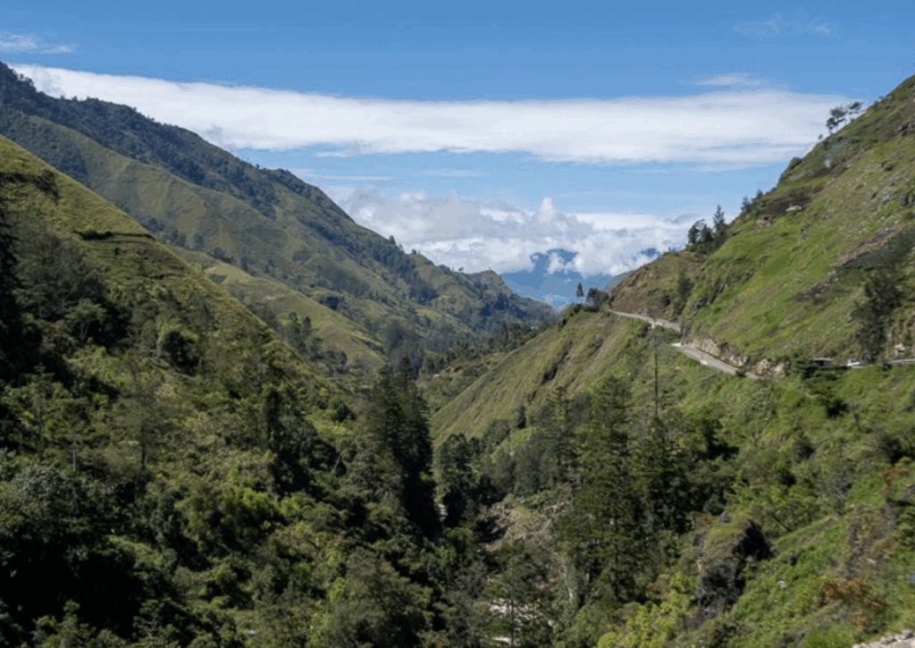
Papua New Guinea Highlands

Project Objective:​

A key goal under Sustainable Development Goal (SDG9) for Papua New Guinea is to develop quality, reliable, sustainable, and resilient infrastructure. This includes regional and transborder road networks aimed at supporting economic growth and enhancing accessibility for all citizens. 

Papua New Guinea currently has a transport network called GoPNG whichhas over 30,000km and 746 bridges with 8,740 kms classified as national roads and about 22,000km as sub-national roads. The national road network is the economic backbone of the country and carries about 89 percent of passenger and freight traffic. However, lack of funding and rehabilitation has contributed to the generally poor state of road conditions. The effects of poor road conditions have led to high vehicle operating and travelling costs and increased road accidents. Many bridges have deteriorated, posing other traffic hazards for public and businesses. 

One of the government’s long-term visions has been to construct a Trans Island Highway that connects the National Capital District with the Highlands region.  

Currently, there are still no roads linking critical agricultural and minerally-rich economic zones. Previous reports (1979 and 2007) have identified five appropriate alignments for the link between Port Moresby and Lae, out of which two routes (identified as Route 1 and Route 4) have been short-listed as the most likely alignments each of about 170 Km long. 

The Challenge

The proposed solution is a 180 km ‘missing link’ corridor project that will form the Trans National Highway, ultimately linking the Highlands Highway to the Hiritano Highway and Port Moresby. Each of the potential alignment follows, in some sections, existing unpaved roads, dirt roads that have been created by the local communities of the region though many years of walking and later driving through parts of the area.  
 
The main issue was related to what is identified as the “Missing Link”, parts of the potential route that traversed through virgin terrain, mostly mountainous and inaccessible. The area is covered with thick local vegetation. It was impossible to complete this project by utilizing on ground survey techniques. In addition, The project was ready for execution when the COVID 19 pandemic started, causing difficulties to travel to and in the country.  

The above conditions called for an approach that would be based on earth observation technologies providing the required data to be able to investigate, identify the route, and provide the preliminary design.   

Our Role

The project involved conducting a route alignment investigation through the utilization of earth observation data collection technologies. Investigations were completed onthe topographic and geological weather related and water related elements, to inform the basis for a preliminary design for the future road that will traverse through the terrain.  

The design had to meet the DOWH minimum design standard for rural road Type I. 

AnyWay Solutions was tasked with conducting a remote, satellite-based investigation and preliminary design of the proposed route. The goal was to meet DoWH’s Rural Road Type I design standards and provide the foundation for detailed engineering and construction planning. 

Our work included: 

– Topographical survey 

– Geological Investigations 

– Hydrological Investigations 

– Preliminary Engineering Design  

– Workshops for the DOWH professional staff, and 

– Prepare and compile bid documents for the proposed works including an estimated BOQ. 

The desktop study involved collecting and analyzing existing data on various factors, including national and local population statistics, geology and soil conditions along the project corridor, the region’s seismic history and potential earthquake risks, as well as historical and projected climatic conditions using modeling techniques. 

The Results

A comprehensive report was produced, detailingt the conditions relevant to road development along the selected project corridor routes.  

The report not only a reviewed the historical and current geological and climatic conditions but also provided detailed technical information and recommended engineering designed solutions in the following areas:  

  1. Pavement design including design speed, road width, horizontal and vertical alignments.
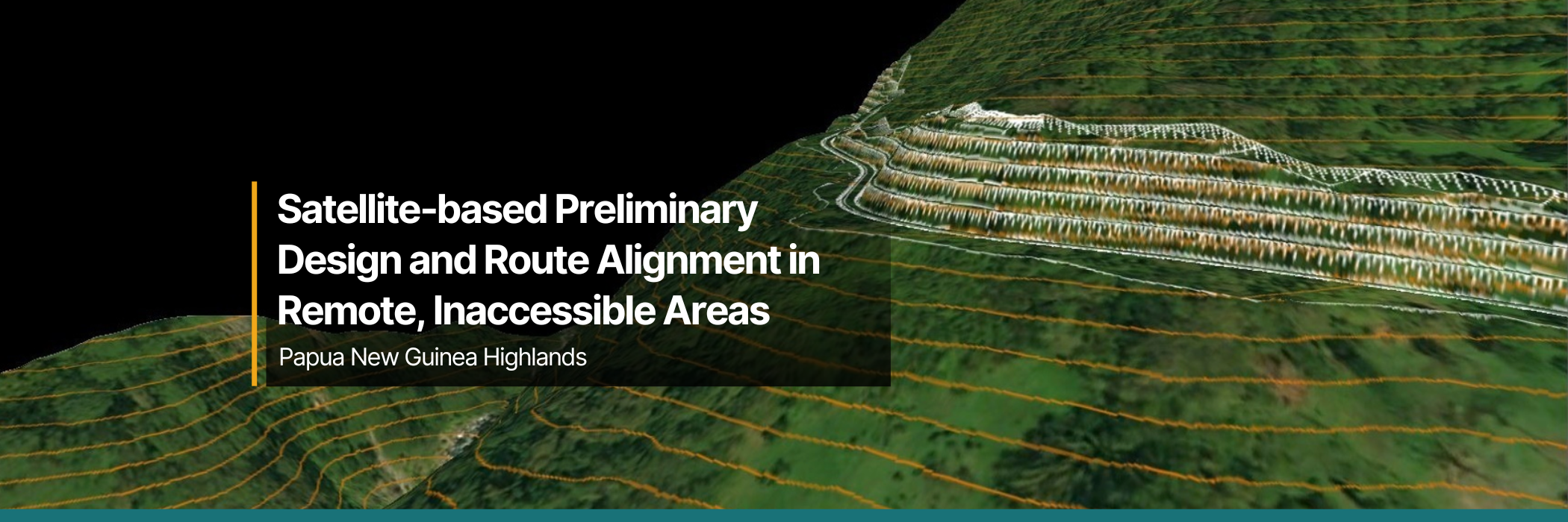
  2. Slope stabilization including analysis of slopes along the potential routes through the use of machine learning and AI applied to satellite collected data. Based on this analysis, engineering solutions were recommended such as reinforced earth structures combined with vegetation to enhance slope stability.
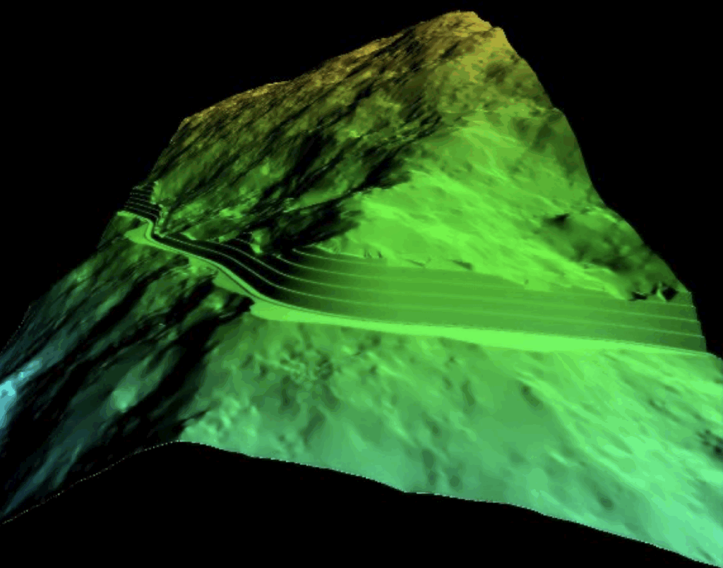
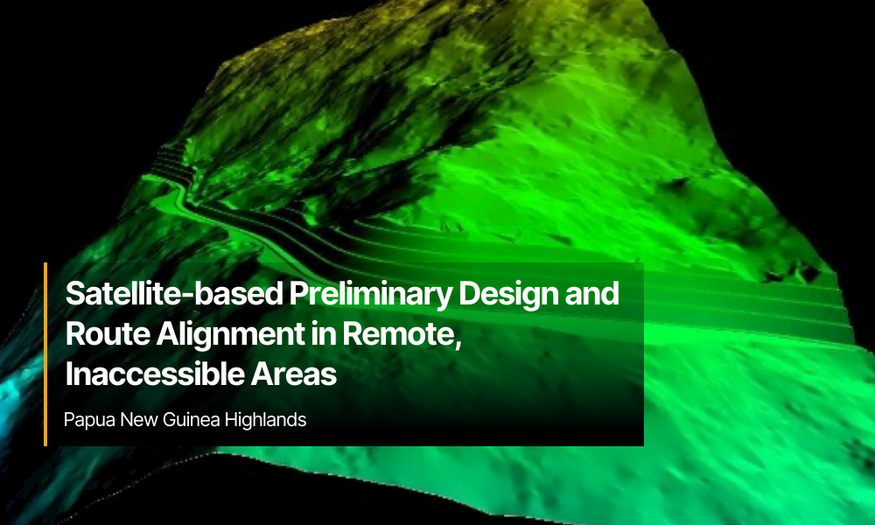
  3. Topographic survey  using high-resolution satellite data, with a focus on elevation mapping through advanced stereo-mapping techniques. This process utilized triple stereo satellite imagery with forward, nadir, and backward views at a resolution of up to 0.3 meters per pixel. A comprehensive, ultra-high-resolution bare earth Digital Elevation Model (DEM), was created which includes accurate stereo-mapping of a bare earth terrain elevation model, cleared from culture features like trees and buildings. This orthophoto is projected on the DTM, in order to create a realistic 3D terrain model, which allows identifying objects such as trees and houses that exist on each point of the mapped area. 
  4. Analysis of catchment areas and specific water ways within the corridor of the project and design of drainage elements required to enhance the climate resiliency of the project that are based on extreme weather conditions futured and not historical data.
  5. Estimated BOQ for the project based on the suggested designs of the route for each of the routes that were analyzed.   

Climate resilient designs and solutions to transport infrastructure is a future-focused approach that utilizes advanced technologies and techniques to overcome harsh project conditions in Papua New Guinea’s remote areas.

The preliminary design of this project allowed the government to select the optimal route for the project, one that will enhance the economic and social aspects of the development of the country, connecting the capital city with the countries main port of entry and many of the rural communities along the selected route.  

AnyWay contributed to the capacity building of the professional staff at the DOWH by sharing information and conducting seminars on the work that was done and the technologies and techniques that were used to create the designs and solutions proposed. This helps equip local professionals with the knowledge to apply similar solutions in future projects.   

Feasibility Study and Route Alignment Optimization

Feasibility Study and Route Alignment Optimization

The Department of Works & Highways (DOWH) - Papua New Guinea

Project Objective:​

The government of Papua New Guinea initiated a program to support the development of rural agricultural areas by improving their connectivity to major roads and regional towns. A central focus of the program is to identify feasible road routes in remote areas of the country with challenging terrain, analyzing conditions and estimating costs for future developments.  

This particular study aimed to determine the most efficient route from Kundiawa, the main town in Jiwaka Province, through Gumine and onward to Karamui. To achieve this, a satellite-based and AI-assisted analysis was conducted to evaluate multiple potential alignments. Each route was assessed based on factors such as cut-and-fill requirements, ease of construction, total length, number of bridges and complex culverts, long-term maintainability, and the population residing along the route. 

This data-driven approach enabled a comprehensive comparison of alternatives, guiding the selection of the most viable option for future development. 

The Challenge

The complex terrain and limited accessibility of the area project area presented significant obstacles for the Department of Works and Highways (DOWH). The remoteness of the region made it it extremely difficult to conduct a traditional feasibility study, collect actionable data, analyze site conditions, and identify optimal routes for future road connections to the agricultural areas of Karamui.  

Given that the program intended to support the development of remote rural areas, timely delivering was critical. However, using conventional, ground-based surveying and data collection methods was not feasible. To move forward, a different approach was required that would help overcome the logistical and environmental challenges that would assist the government in relatively short time frame.  

Our Role

A preliminary evaluation of the various routes was required prior to undertaking a more detailed, and costly, pavement design and route alignment optimization study. The feasibility study needed to assess the construction complexity of each route segment to support an informed decision on the most viable option for unlocking the agricultural potential of the region. 

To assess the potential routes, a 3 km corridor was created around the existing and proposed route locations. A custom Digital Terrain Model (DTM) was created for all corridors using high-definition satellite imagery, which was utilized to assess existing infrastructure and regional hydrology.  

Once the DTM was acquired, specialized civil engineering software integrating AI tools constrained according to the client’s design parameters was utilized. The AI tool uses algorithms to search in real-time for the most cost-effective routes. Once an optimal route was identified, the corridor was defined. Further patented algorithms are then used to determine the most cost-effective profile within the design parameters. 

This phase also involved acquiring high-resolution (>1m per pixel) geo-referenced stereo imagery. Images were captured using forward, nadir and backward satellite images of the designated areas ensuring tht each point on the terrain was viewed from multiple perspectives. This stereo acquisition mode enabled the generation of Digital Elevation Models (DEMs) through stereo matching techniques.  

Once the DEM was developed, digital drainage channels were mapped across the terrain and overlaid onto the road corridor. where the channels intersected, the catchment area was calculated. The data was then used to estimate peak discharge for a given return period. Although rainfall and stream data in the area are not available or accurate to the current regional climate, the Papua New Guinea Flood Estimation Guidelines from August 2018 provided methodologies and formulas for peak discharge calculations even with limited data.  

To ensure that infrastructure investment delivers maximum benefit, it was essential to evaluate the potential socioeconomic impact of each route. Artificial Intelligence algorithms were used to identify structures (eg: rooftops) within each corridor and assess the communities directly within the vicinity of the new routes. The algorithm reports accuracy of up to 90%. 

The Results

The most efficient route between Kundiawa to Karamui was optimized with the goal of opening up the region for agricultural development. Multiple route options were analyzed using cut-and-fill analysis, evaluating ease of construction, length, number of bridges and complex culverts, maintainability, and the population along the route. A recommendation was made for a new alignment that uses some of the existing road, but deviates to create shallower slopes and better lines of sight. The recommended alternative routing from Kundiawa to Gumine is 5km shorter and has 36% less horizontal curves within the realigned segment. However, the benefits from the improvements must be weighed against the cost and complexity of establishing a new right of way.  

Additionally, it is recommended to expand the area of investigation for the eastern route alignment South and East toward Naiyo and Wario, as this might also significantly reduce the cost of construction if the eastern route. Beyond the design considerations of the two routes, the western route services 226 structures within communities (e.g. houses), while the eastern route services 4827 structures within communities. As such, the eastern route will service a greater population in the region and provide greater support for regional development.  

A further recommendation was made to conduct a more detailed design assessment, incorporating factors such as slope stability, materials availability, geological considerations, and refined hydrological factors to ensure that the route is one that provides the level of service that the region requires, and without creating a long-term maintenance and rehabilitation legacy.

Added value from AnyWay Solutions 

AnyWay’s use of satellite-based earth observation, combined with AI-driven route analysis, advanced flood modeling, and catchment area assessments, played a key role in evaluating the feasibility and optimizing the alignment of the proposed road. 

Through this optimization process, it became clear that a new alignment that partially follows the existing road but deviates to achieve shallower slopes and improved visibility, would offer significant advantages in terms of safety, constructability, and long-term performance. 

As a result, we were able to recommend alternative routes that better align with the project’s long-term development goals and improve connectivity of communities in the area. 

Enga Highway Impact Assessment: Overcoming the Challenges of Manual Data Collection 

Enga Highway Impact Assessment: Overcoming the Challenges of Manual Data Collection

Figure 1: Meeting with the survey data collection team in Wabag, with productive discussions in preparation for the field data collection. 
Figure 2: Group photo with Pawssa High School students During interviews and data collection in Enga Province. 
Figure 3: Group photo with bus drivers and support crew during interviews and data collection in Mount Hagen, Western Highlands Province. 

Enga Highway Impact Assessment

The Enga Highway Impact Assessment project is a collaborative initiative between AnyWay Solutions and Rural Senses, designed at evaluating the environmental, social, and economic impact of transportation infrastructure along Papua New Guinea’s Enga Highway corridor. By integrating community-centered impact evaluation with AI-enhanced analysis, the project assesses real-world outcomes aligned with the UN Sustainable Development Goals.

Learn more here: https://anywaysolutions.com/rural-senses-impact-assessment-building-a-theory-of-change/ 

Understanding Impact Beyond the Numbers 
Investments in infrastructure now can help regions to capitalize and prepare for population growth. Instead of rebuilding roads using difficult-to-procure, expensive materials, rehabilitation is often a good solution to improve road networks with less time and capital investments. Rehabilitation of highly distressed roads using recycling and stabilization can be an effective long-term strategy for pavement performance to withstand rigorous climate impacts. Lifecycle costs are minimized using this method as it is less costly to pay for the maintenance and upkeep of rehabilitated roads.  

While Earth Observation (EO) and satellite analytics provide valuable quantitative data, they cannot fully capture the lived experiences of communities. To understand changes in livelihoods, access to services, and public perception, we rely on in-depth, qualitative, on-the-ground data collection. 

In our latest phase, we engaged with communities along the Enga Highway, interviewing farmers, transport operators, students, and local organizations. Each survey question is tied to specific indicators that allow us to track and measure real-world change. 

As we continue collecting data, our understanding of the highway’s impact becomes clearer and more evidence-based, transitioning from initial insights to verified results. 

Key Challenges and How We Overcame Them 

Conducting large-scale qualitative research in remote areas brings unique logistical and operational hurdles. Here’s how we addressed them: 

1. Translation of Interviews 

Out of the 3,888 scheduled interviews, 790 require transcription and translation from Tok Pisin to English. While an internal team member leads this task, we’ve also engaged local translation experts to ensure cultural and linguistic nuances are preserved—crucial for accurate analysis and integration with EO data. 

2. Limited Access to Government Records 

Key official records such as traffic counts, maintenance logs, and economic data were often unavailable due to weak documentation systems and staff unavailability. To bridge this gap, we triangulated insights from community interviews and local leaders, helping us validate trends and timelines in the absence of formal data. 

3. Staffing and Connectivity Issues in Wabag 

Poor network connectivity and reliance on part-time field assistants in Wabag disrupted coordination and slowed progress. In response, we embedded a full-time AnyWay Solutions team member on-site to improve supervision, communication, and data quality. During this process, we experienced many on-the-ground challenges of largescale qualitative data gathering in a remote setting and have adapted to strengthen rigor and reliability. 

Strengthening Credibility Through Human-Centered Data 

With the continued support of Rural Senses, we’re addressing linguistic, institutional, and logistical barriers to ensure a high-quality, community-informed impact assessment. This work is about listening to local voices and making them a core part of the evaluation. By integrating first-hand narratives with satellite imagery and structured indicators, we’re building a multidimensional understanding of how infrastructure affects people’s lives. Our shared goal remains: Human-Centered AI—using technology to amplify, not replace, the voices of communities.